Geodata International
Geodata International - Wereldwijd steden, gemeenten en postcodes
Geodata International - Wereldwijde database van landen met een geogerefereerde steden, gemeenten, postcodes en administratieve eenheden met WGS84 en UTM coördinaten en hoogtes voor geocodering, nabijheid zoeken, navigatie, afstand berekening. Vaak is noodzakelijk, want een adres kenmerk, bijvoorbeeld de plaatsnaam of de postcode, naar een lokale relatie op te bouwen - een georefereren. De georeferentie kan bijvoorbeeld gebruikt worden om een ??klant te tonen de dichtstbijzijnde winkelketen door het doen van een proximity zoeken. Op basis van de georeferences zakelijke zones, kunnen de statistieken of algemene kaarten worden gemaakt. Steden, gemeenten en postcodes kunnen worden toegewezen aan de superordinated administratieve eenheden. Afstanden tussen plaatsen of post gebieden kan worden bepaald met de coördinaten die in de database tabellen. Voor dat de georeferences beschikbaar zijn in alle landen database-tabellen als UTM coördinaten op de natuurlijke en een gelijkmatig meridiaan strip en als geografische coördinaten in graad en deg / min / sec notatie. Met de hoogte van gegevens van een Digital Elevation Model de begane grond hoogte van elke plaats kan worden bepaald. De database tabellen zijn aanwezig in de bestandsindeling CSV (Comma Separated Values). De gebruikte tekenset is UTF8. Dit formaat wordt vaak gebruikt en in de meeste gevallen kunt u direct gegevens importeren in uw eigen gegevens systeem. Het freeware programma CONVERT, te downloaden van de KilletSoft site, zet de beschikbare database tabellen voor andere data formaten en tekensets met de nodige sorteringen en selecties. Met het programma, bijvoorbeeld, kan CSV-gegevens worden omgezet in de SDF-formaat (Simple Document Format) of naar het dBase-formaat. Voor het gebruik van de gegevens op verschillende platforms is het mogelijk om te kiezen tussen de tekensets ASCII, ANSI, UTF8 en Unicode. Dus de invoer van de gegevens in een database management systeem of file-systeem zal het mogelijk zijn.
Veranderingen: February: All databases actualized on level 1st January 2020. February: Coordinate System Google Plus Codes added. New country files on the African and Australasian continent. World time UTC_DIF is determined very precisely by a shape file. New country group "Middle East".
Minimum eisen: All systems
Besturingssysteem: WinXP,Win7 x32,Win7 x64,Windows 8,Windows 10,Windows2003,Windows Server 2003,Windows Server 2008,Windows Server 2008r2,Windows Server 2012,Windows Tablet PC Edition 2005,Windows Media Center Edition 2005,WinVista,Windows Vista Starter,Windows Vista Home Basic,Windows Vista Home Premium,Windows Vista Business,Windows Vista Enterprise,Windows Vista Ultimate,WinVista x64,Windows Vista Home Basic x64,Windows Vista Home Premium x64,Windows Vista Business x64,Windows Vista Enterprise x64,Windows Vista Ultimate x64,Linux,Linux Console,Linux Gnome,Linux GPL,Linux Open Source,Mac OS X,Mac OS X 10.1,Mac OS X 10.2,Mac OS X 10.3,Mac OS X 10.4,Mac OS X 10.5,Mac OS X 10.6,Mac OS X 10.7,Mac OS X 10.8,Mac OS X 10.9,Android,iPhone,iPad,iOS
Programma-URL: https://www.killetsoft.de/p_igda_e.htm
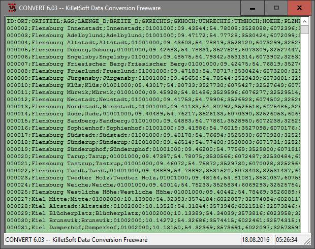
Geodata International screenshot
Persbericht: Geodata International - World-wide towns, town quarters, postal codes with georeferences.
Geodata International is a database of world-wide countries with georeferenced places, postal codes and more with WGS84 and UTM coordinates and elevations.
Speciale toestemmingen
Hereby Killet Softwareentwickung GbR permits to distribute their software "Geo data Europe and International countries" exclusive as shareware version on data media and in the online media up to revocation. We guarantee to possess all rights on the software. We exempt the legal distributor of our software from requirements third. With the revocation of the permission all projects in work with our software may be led to the end.
EULA
The license models described here require only a unique payment. No additional payments are raised as a function of the number of installations or on the service life of the license. The service life is unlimited. The data of the presented country data base tables can be used as data volumes of computer programs and Internet sites (applications) and can be passed in the context of the application to customers.