TRANSDAT
TRANSDAT coördineren conversie en Datumverschuiving met hoogste nauwkeurigheid
TRANSDAT geosoftware voert coördinaat transformaties en geodetisch datum verschuivingen tussen veel coördinaat en referentie systemen van Amerika, Australië, Europa, Duitsland speciale en wereldwijd, met hoge precisie en hoge snelheid: 1. de huidige en historische coördineren en verwijzen naar systemen van alle landen van de Europese Unie (EU), met inbegrip van de Oost-extensies en de systemen van niet-EU-landen. 2. De INSPIRE gesteunde Europese ETRS89 systemen. 3. De Amerikaanse en Canadese staat vliegtuig Coordinate Systems (SPC) op NAD27 en NAD83 en andere coördinatensystemen van het Noord Amerikaanse continent. 4. De coördinaat en referentie systemen van de Australasian continent. 5. Veel coördinaat en referentie systemen van de landen van andere continenten. 6. World-wide NTv2 raster bestand ondersteund coördinaat transformaties. 7. Alle globale coördinaat en referentie-systemen. 8. De Duitse coördinaat en referentie systemen van de oude en de nieuwe federale staten, de 40 Pruisische Soldner Land Registers, de Duitse Lagestatus en exacte referentiesystemen van de Duitse deelstaten. U vindt een complete lijst van de coördinaat en referentie-systemen ondersteund door het programma op het web of na het downloaden van de gratis testversie van het programma. De standaard NTv2 met national grid bestanden is wereldwijd volledig ondersteund. Afgezien van de gegeven world-wide en staatspecifieke systemen, uw eigen persoonlijke coördinaat systemen en geodetisch referentiesystemen met Helmert kunnen worden gedefinieerd (Bursa / Wolf, ISO 19111) of Molodensky parameters. Berekeningen kunnen worden uitgevoerd met coördinaten rechtstreeks ingevoerd, geladen vanuit bestanden in verschillende formaten (tekst, CSV, SDF, dBase, KML, ArcShape, ArcGenerate) of doorgegeven door batch-verwerking. ArcShape bestanden kunnen worden bekeken met de interne vorm Viewer. Een programmeerbare GPS-interface maakt het mogelijk om te lezen van de coördinaten van een low-cost GPS antenne.
Veranderingen: New NTv2 systems for German Federal States Berlin, Bavaria and Mecklenburg. New CRS for Czechia, Slovakia, Albania, Cyprus and Switzerland. Digital signature for secure installation of the program. New internal Text Viewer and dBase Browser. New Serial Interface Monitor diplays GPS dataflow.
Minimum eisen: Pentium, 30 MB free HD
Besturingssysteem: Win2000,WinXP,Win7 x32,Win7 x64,Windows 8,Windows 10,WinServer,WinOther,Windows2000,Windows2003,Windows Server 2012,Windows Tablet PC Edition 2005,Windows Media Center Edition 2005,WinVista,Windows Vista Starter,Windows Vista Home Basic,Windows Vista Home Premium,Windows Vista Business,Windows Vista Enterprise,Windows Vista Ultimate,WinVista x64,Windows Vista Home Basic x64,Windows Vista Home Premium x64,Windows Vista Business x64,Windows Vista Enterprise x64,Windows Vista Ultimate x64
Programma-URL: http://www.killetsoft.de/p_trda_e.htm
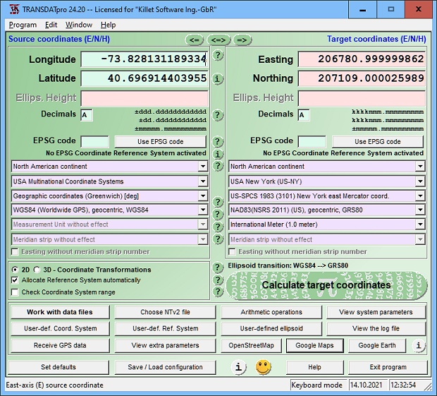
TRANSDAT screenshot
The author presents a simple method for realizing polygonal validity scopes in NTv2 files. Thereby the structure of the NTv2 file remains unchanged.
Speciale toestemmingen
Hereby C. Killet Softwareentwickung GbR permits to distribute their software TRANSDAT exclusive as shareware version on data media and in the online media up to revocation. We guarantee to possess all rights on the software. We exempt the legal distributor of our software from requirements third. With the revocation of the permission all projects in work with our software may be led to the end.
EULA
A single program license entitles the license holder to use the program on a single computer in the license holders place of work. A network program license entitles the license holder to use the program on a single network of the license holders principal branch/subsidiary office. A general program license entitles the license holder to use the program on all computers and networks of the license holders branch/subsidiary office.